
 Congress established Hot Springs Reservation on April 20, 1832 to protect hot springs flowing from the southwestern slope of Hot Springs Mountain. This makes it the oldest park currently in the National Park System–40 years older than Yellowstone National Park. People have used the hot spring water in therapeutic baths for more than two hundred years to treat rheumatism and other ailments. The reservation eventually developed into a well-known resort nicknamed “The American Spa” because it attracted not only the wealthy but also indigent health seekers from around the world. Today the park protects eight historic bathhouses with the former luxurious Fordyce Bathhouse housing the park visitor center. The entire “Bathhouse Row” area is a National Historic Landmark District that contains the grandest collection of bathhouses of its kind in North America. By protecting the 47 hot springs and their watershed, the National Park Service continues to provide visitors with historic leisure activities such as hiking, picnicking, and scenic drives. Hot Springs Reservation became Hot Springs National Park by a Congressional name change on March 4, 1921
Wildlife within the park is typical of the region, consisting mostly of rodents, bats, and other small mammals. Because of the region’s mild climate, bird species are varied and plentiful. Aquatic resources are limited to portions of several small creeks and are void of significant game fish. No endangered or threatened animal species are known to live in the park.
The hot springs are the primary natural resource of the park, but they have not been preserved in their unaltered state as natural surface phenomena. They have instead been managed to conserve the production of uncontaminated hot water for public use. The mountains within the park are also managed within this conservation philosophy in order to preserve the hydrological system that feeds the springs.
The park and its surrounding mountains exhibit a south-central United States pine-oak-hickory forest ecosystem. The park’s vegetation, thermal waters, cold water springs, bathhouses and associated cultural features, foot trails, prehistoric and historic novaculite quarries, and general physiography combine to form an almost 5400 acre area of resource preservation and interpretation that is under the exclusive legislative jurisdiction of the federal government. Another 672.69 acres are within the park boundary but are not federally owned. The city of Hot Springs, Arkansas, with an approximate population of 33,000, lies immediately outside the park and exerts a significant influence on it.
Hot Springs National Park surrounds the north end of the city of Hot Springs with a population of 33,000. Although some park boundaries are bordered by undeveloped forested lands, much of the park is adjacent to city streets and homes. These areas are subject to air pollution, exotic plant and animal species, and trash dumping. The park is an island of green in the developed downtown area.Resource inventories are currently underway to better prepare for the protection of the park’s natural resources.
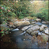
Outside of the Bathhouse/Grand Promenade historic areas, Hot Springs National Park is primarily forested hills and valleys. The oak-hickory-pine forest type includes many other tree and shrub species. Wildflowers and blooming trees are especially beautiful in spring, while autumn brings many bright colors of leaves
Hot Springs National Park is in the Zigzag Mountains, a small range of the Ouachita (Wash’-i-tah)Mountain system in the Interior Highlands, which form the only major topographic relief for a vast area of the midwestern and south-central United States. The topography was formed in late Paleozoic times (400 million years ago) by tremendous geological forces that acted to uplift, fold, fault, fracture, and harden inland seabed sediments. Subsequent erosion has led to the formation of the present ridge and valley landscape. The narrow steep ridges of the Zigzag Mountains, are capped with novaculite rock outcrops. These outcrops are unique to the Ouachita Mountains, and the finely grained structure of the novaculite is known for its superior quality as a natural whetstone
The Forgotten Expedition of Dunbar and Hunter Exploring a New Territory
In 1803, this area joined the United States of America with the purchase of the Louisiana Territory from France. What was in this vast “wilderness”? French explorers and fur trappers had been up and down the streams of this country and Spanish explorers had mapped it as well. President Thomas Jefferson wanted to know more about Louisiana and began making plans for Americans to explore it.
Jefferson was interested in the Red and Arkansas Rivers, southern tributaries of the Mississippi, and wrote to William Dunbar of Natchez, Mississippi, about leading an exploratory party. There was too much unrest with the American Indians and Spanish along the Red River, the southwestern border of the territory, so Dunbar suggested a shorter trip to “the hot springs on the Washita.” Jefferson agreed and recommended Dr. George Hunter, a Philadelphia chemist, as the second principal. This first scientific expedition into the new territory set out from Natchez, Mississippi, on October 16, 1804, traveling down the Mississippi River to the mouth of the Red River, then upstream a short distance to the Black River, and finally to the mouth of the Ouachita River.
The Party and the Route
Along with Dunbar and Hunter, the party consisted of a sergeant and 12 enlisted men from the garrison at New Orleans (Sergeant Bundy, Peter Bowers, John White, Robert Wilson, Mathew Boon, William Court, Edward Rylet, Jerimiah Loper, William Skinner, William Little, William Tutle, Manus McDonald, Jeremia Smith), Hunter’s son George, Samual Blazier as a guide, and Dunbar’s slave. They traveled up the Ouachita River for 21 days before reaching the next settlement, “the post on the Ouachita,” Ft. Miró, the site of present day Monroe, Louisiana
This “Chinese-style” boat was purchased by Dr. Hunter in Pittsburgh for the expedition, but sat too deep in the water for the smaller streams. Dunbar rented a more suitable boat at “Post d’Ouachita” before continuing.
They then traveled 25 days from Ft. Miro before reaching the mouth of Gulpha Creek. There were a number of rapids on the Ouachita River, but one of the worst was near present-day Rockport. Here’s what Dunbar’s journal says about their getting past it:
December 3rd, 1804
“…we were now anxious to see the famous Chutes, which it was supposed at the Post, we could never be able to pass with so large a boat….A little after 4 p.m. we arrived at the Chutes. We found these falls to be occasioned by a chain of rocks…, here they extended quite across the river, the water making its way over the chain thro’ a number of breaches, which by the impetuosity of the torrent had been worn out of the rock….The various breaches, thro’ one of which it was necessary to pass; otherwise the barge must remain below the Chutes….it was also doubtful whether our barge (9 feet wide) could find sufficient breadth and depth of water clear of pointed rocks to pass over the Chutes. We came up to the rock and stopped between two of the Cascades, and sent a couple of men with a small Canoe, who crept along shore and got above the Fall. They made fast a rope to a tree, and letting themselves gradually down by the same rope,came on board in great safety. Having now got a number hands ready to haul in upon the rope, we employed the remainder with poles to give a proper position to the Barge and to guide her into the best passage. We accordingly entered one of the Cascades, but after many fruitless attempts, we found there was a deficiency of water, with some pointed rocks which opposed our passage. We therefore dropped down a little way, and moved laterally by poling to a second Cataract much more considerable than the one we had just attempted. The rolling impetuaosity of the water is not easy to describe, above and below the fall there was a rapid descent, but just at the fall there seemed to be a step of nearly one foot perpendicular. Difficult and dangerous as this place appeared for a frail bark like ours, we were determined to make the attempt and we lost no time in entering the strait, in which our Barge soon stuck fast at the bows. We then concluded it would be impossible to pass. It seemed that an inch or two were just wanting to our success. We however continued our efforts by moving from side to side by the stern, while great efforts were making upon the rope. We perceived a small advancement by every new exertion, our hopes revived, the Barge was in this manner forced half way thro’ the Cascade. And now she seemed so completely wedged into the narrow passage, that every effort to stir her in any direction proved ineffectual. The water tho’ extremely rapid was not deep and we got four of our boldest men into the water at her bows, as far as possible from the suction of the fall, who by feeling for rocks on which she rested, and raising her sides with their might, enabled us to advance a step or two farther, beyond which it seemed impossible to move. It was now night, the stars were visible, the water was cold, and altho’ the weather was not freezing, it was far from being mild, the thermometer being at 45°. We now repented that we had made the attempt to pass so late in the evening and wished we had delayed until the morning. At the same time the river was falling, and it seemed not proper to defer the attempt, lest we should not get above the Chutes until another swell of the river.” A man was sent on board to lighten the vessel and discovered that the strain on the rope had nearly severed it. All men were ordered onto the boat to their poles to support the vessel until another rope was tied to the tree. Men were sent to river bank to pull and safely pulled the vessel safely ashore, “greatly rejoicing to find ourselves without accident above the Chutes.”
Discoveries
Along the journey, Dunbar and Hunter took astonomical readings for use in plotting the route after their return. They also made observations about the plants and wildlife that they encountered, as well as the mineral resources. Abundant natural resources would be necessary to the success of settlers in the new territory.
One of the most important discoveries was a source of rock suitable for whetstones for knife sharpening. This Arkansas novaculite became the primary source for whetstones by the mid-1800s and remained the main source until the advent of the manufacture of artificial whetstones in the 1970s.
At the Hot Springs
The party camped at the hot springs from December 9, 1804, until January 8, 1805. Dunbar and Hunter improved a cabin built for summer use and stayed in it while the enlisted men camped. Dunbar reported to President Jefferson that “… the hot springs themselves are indeed a great curiosity; the temperature of their waters is from 130 to 150° of Farheneits’ [sic] thermometer. The heat is supposed to be greater in summer, particularly in dry weather. In water of 130° which was comparatively in a state of repose to one side of the spring run, I found by the aid of an excellent microscope, both Vegetable and animal life, the first a species of moss, the latter a testaceous bivalve of the size of the minutest grain of Sand.” Dunbar was referring to the algae and ostracods that live in the hot spring pool
In his journal, Dr. Hunter pondered the cause of the heat of the springs. He speculated, “Those scisti containing clay, iron, Bitumen silex and sulphur by the action of air and water generate heat, sometimes take fire, the sulphur being converted into sulphuric acid, seizes the clay and forms Alumn. Is this water heated by some such chemical mixture or combination, and thereby forced in the state of vapor to the upper internal cavaties or regions of the mountain, where it is condensed again into water as in the refrigitory of anAlembic, whence it falls again and issues throu such apertures as present themselves very hot yet still many degrees below boiling water?
Of the hot springs, Dunbar wrote, “I shall only mention that from our analysis of the water of the hot springs, it appears to contain lime with a minute portion of iron disolved [sic] by a small excess of Carbonic acid: this is indeed visible upon first view of the Springs. An immense body of Calcareous matter is accumulated upon the side of the hill, by the perpetual depositions from the hot waters, and the bed of the run is coloured [sic] by red oxid [sic] of iron or rather Carbonated iron. Every little spring which rises up in a favorable situation, forms its own calcareous cup, considerably elevated in form of a Crater.”
Going Home
The return trip to Ft. Miró only took 8 days. From Ft. Miró, Dunbar took leave of the party and traveled overland to his home near Natchez. Hunter and the enlisted men continued on to New Orleans.
Records of the Journey
Both men’s journals are in the archives of the American Philosophical Society in Philadelphia, the repository of scientific papers and materials of the day. Dunbar’s original journal is in the Ouachita Baptist University archives. The plant and animal specimens collected by Dunbar and Hunter have disappeared.
William Dunbar died in 1810 and is buried near Natchez. George Hunter moved his family from Philadelphia to New Orleans shortly after the expedition and died there in 1823
Hot Springs National Park (National Park Service
http://www.nps.gov/hosp/index.htm